


Imray 2100 Kent and Sussex Coasts Chart Pack
- Article number:
- EA2925-AF-35
- SKU:
- YOT0851
Fast Delivery
Fast & Fully Trackable As StandardExtended Returns
Return up to 90 days after purchase.Bricks & Mortar Shop
One Of The Largest - Come And See Us - We're Not Just OnlineCustomer Service Guaranteed
Established in 1991 & Trusted By Thousands For Over 30 years.
Product Description
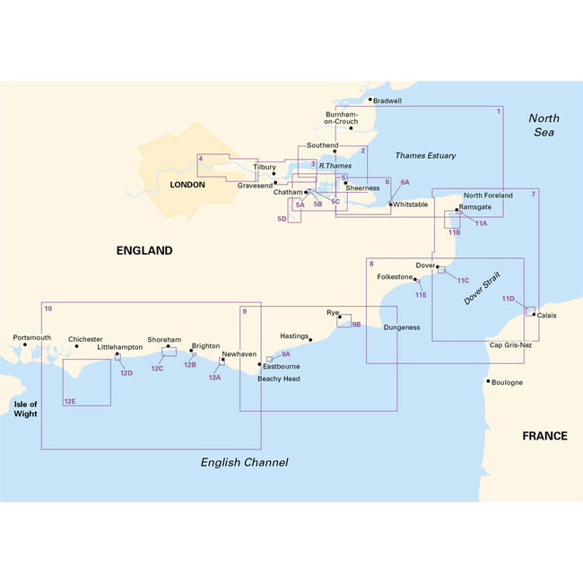
Imray's 2100 Kent and Sussex Coasts Chart Pack covers areas from the Thames Estuary to the Solent. For this edition, the latest depth surveys have been applied and the latest wind farm information is included where relevant. There has also been general updating throughout. Tidal stream information included.
Printed and corrected to February 2018.
The chart pack includes:
2100.1 Thames Estuary South
1: 120 000 WGS 84
2100.2 River Thames Sea Reach
1: 50 000 WGS 84
2100.3 The River Thames - Queen Elizabeth Bridge to Canvey Island
1: 35 000 WGS 84
Plans Coalhouse Point to Canvey Island, Queen Elizabeth II Bridge to Coalhouse Point
2100.4 The River Thames - Tower Bridge to Queen Elizabeth Bridge
1: 35 000 WGS 84
Plans Barking Creek to Queen Elizabeth II Bridge, Tower Bridge to Barking Creek
2100.5 River Medway
1: 40 000 WGS 84
Plans Gillingham Marina, Port Werburgh, Whitton Marine, Continuation of River Medway
2100.6 The Swale
1: 40 000 WGS 84
Plans Whitstable Harbour
2100.7 North Foreland to Dover & Calais
1: 115 000 WGS 84
2100.8 Dover to Dungeness & Cap Gris-Nez
1: 115 000 WGS 84
2100.9 Beachy Head to Dungeness
1: 115 000 WGS 84
Plans Sovereign Harbour, Rye Harbour
2100.10 Nab Tower to Beachy Head
1: 160 000 WGS 84
2100.11 Kent Plans - including plan of Calais
1: various WGS 84
Plans Ramsgate, River Stour Entrance, Dover, Calais, Folkestone
2100.12 Sussex Plans
1: various WGS 84
Plans Newhaven, Brighton Marina, Shoreham Harbour, Littlehampton, The Looe